GNSS Products
As one of the analysis centers of the International GNSS Service (IGS), we process millions of GNSS observations each day to derive precise station coordinates, satellite orbits, satellite clock corrections, Earth rotation parameters, and global ionosphere maps. In line with the current IGS product policy, we provide geodetic products in ultra-rapid (latency 3-9h; GPS, GLONASS, Galileo), rapid (latency (1 day; GPS, GLONASS, Galileo), and final (latency two weeks; GPS and GLONASS) mode.
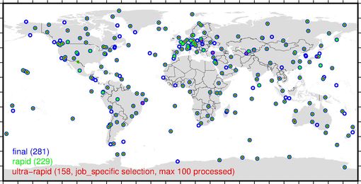
All three processing lines follow the same strategy. Based on a well-defined subset of IGS tracking stations (see Figure 1), a least-squares adjustment is used to derive the unknowns. Within this network approach, satellite orbits and clock corrections (i.e., deviation of the satellite clock with respect to the GPS time) are determined. For GPS observations, phase ambiguities are fixed. The generation of IGS products follows the least-squares adjustment and depends on the processing line. The ultra-rapid line provides orbits (15-minute sampling) and clock corrections (5-minute sampling) only but includes predictions for both for the next 24h. These products are of interest to users with real-time or near real-time applications. The daily processing also provides orbit and clock corrections but also Earth rotation parameters. The most precise results are derived in the final processing carried out for the latest week. Here, orbits are determined by stacking daily orbits to three-day arcs, which minimize orbit jumps at the day boundaries. Satellite clocks are also provided with 30-second sampling, which is very helpful for PPP users. In addition, Earth rotation parameters are determined. Station coordinates are provided in the SINEX format. All products are given in the current reference frame (i.e., IGS20 since November 28th 2022, before IGb14). A detailed description of our GNSS processing strategy can be found in the GFZ Analysis Center Notes. With the switch to IGS20/igs20.atx (as of November 28th, 2022) the operational products are updated to the repro3 standards (see below).
In separate rapid and final processing lines, global ionophere maps are computed from around 250 IGS tracking stations. Both lines provide daily solutions of the vertical total electron content (VTEC) of the Earth's ionosphere with a temporal resolution of 2 hours and a spatial resolution of 2.5 degrees in latitude and 5 degrees in longitude (Brack et al., 2021). The final solution contains the middle day of a combination of the rapid solutions of three consecutive days. The processing is based on a rigorous least-squares approach using uncombined code and phase observations, and does not entail leveling techniques. A single-layer ionospheric model with a spherical harmonic VTEC representation is applied.
The processing and product generation is performed using the GFZ developed EPOS.P8 software, which is in line with the current geodetic conventions. Our product's high accuracy is ensured by the comparisons and combinations done by the IGS Analysis Center Coordinator.
GFZ contributed also to the third reprocessing campaign of the International GNSS Service. For the first time, the reprocessing included three systems (GPS, GLONASS, and Galileo). To ensure the highest accuracy and consistency the IERS2010 conventions are applied. Compared to previous reprocessing efforts the following models were updated:
- (linear) mean pole for computing the rotational deformation (pole tide),
- ocean loading model (FES2014b),
- sub-daily EOP model (Desai and Sibois, 2016),
- time-variable gravity field (GOCO6s)
- receiving antenna phase center corrections for all signals (igsR3_2077.atx).
Our reprocessed solutions contributes to the IGS submission for the ITRF2020. Männel et al. (2019) summarized the results of the initial test campaign. Along with the repro3 activities, GFZ contributed also to the reprocessing efforts within the IGS Tide Gauge Benchmark Monitoring Pilot Project (TIGA). The dedicated products (station coordinates, troposphere) were derived within the repro3 framework by using the GFZ repro3 orbit and clock products.

Product References
- operational products:
- final: Männel, B., Brandt, A., Nischan, T., Brack, A., Sakic, P., Bradke, M. (2020): GFZ final product series for the International GNSS Service (IGS). GFZ Data Services. https://doi.org/10.5880/GFZ.1.1.2020.002
- rapid: Männel, B., Brandt, A., Nischan, T., Brack, A., Sakic, P., Bradke, M. (2020): GFZ rapid product series for the IGS. GFZ Data Services. https://doi.org/10.5880/GFZ.1.1.2020.003
- ultra-rapid: Männel, B., Brandt, A., Nischan, T., Brack, A., Sakic, P., Bradke, M. (2020): GFZ ultra-rapid product series for the IGS. GFZ Data Services. https://doi.org/10.5880/GFZ.1.1.2020.004
- ionosphere products:
- Brack, A., Männel, B., Bradke, M., Brandt, A., Nischan, T. (2021): GFZ Global Ionosphere Maps. V. 1.0. GFZ Data Services. doi.org/10.5880/GFZ.1.1.2021.006
- Brack, A., Männel, B., Wickert, J., Schuh, H. (2021) Operational Multi-GNSS Global Ionosphere Maps at GFZ Derived from Uncombined Code and Phase Observations, Radio Sciences, Radio Science, 56, e2021RS007337. doi.org/10.1029/2021RS007337
- repro3:
- Männel, B., Brandt, A., Bradke, M., Sakic, P., Brack, A., Nischan, T. (2021): GFZ repro3 product series for the International GNSS Service (IGS). GFZ Data Services. doi.org/10.5880/GFZ.1.1.2021.001
- Männel B., Brandt A., Bradke M., Sakic P., Brack A., Nischan T. (2020) Status of IGS Reprocessing Activities at GFZ. In: International Association of Geodesy Symposia. Springer, Berlin, Heidelberg, https://doi.org/10.1007/1345_2020_98
- tiga3:
- Männel, Benjamin; Schöne, Tilo; Bradke, Markus (2022): GFZ reprocessing product series for the IGS Tide Gauge Benchmark Monitoring. GFZ Data Services. doi.org/10.5880/GFZ.1.1.2022.001
Product types
| Product | Ultra-rapid line | Rapid line | Final line | Repro3 | Tiga3 |
| Systems | GRE | GRE | GR | GRE | G |
| Satellite orbit | x | x | x | x | |
| Satellite clock correction | x | x | x | ||
| Station coordinates | x | x | x | ||
| Troposphere delay and gradients | x | x | |||
| Earth rotation parameters | x | x | x | x | |
| Spacecraft attitude | x | ||||
| Bias information file | x | ||||
| Global ionosphere maps | (x) | (x) |
Please note: the ionosphere products are computed in separate processing lines and contain GPS, GLONASS, and Galileo.

